Turkey Feels Impacts from the Largest Earthquake in 80+ Years
Residents of Turkey and Syria felt impacts from a magnitude 7.8 earthquake on Monday, February 6 - the largest in 84 years for the area.

On February 6, 2023, around 4:15 local time, residents near south central Turkey (towards the Syrian border) were struck by a magnitude 7.8 earthquake. The earthquake lasted approximately two minutes. 11 minutes later, another followed- a magnitude 7.5 earthquake. Some believe this was an aftershock of the first one. Others believe that due to the cluster of activity being different among the two, the magnitude 7.5 earthquake may have been a separate earthquake along the fault.
Over 100 aftershocks have been recorded since. Thousands of buildings have collapsed and more than 12,000 have died as a result. The quake was the strongest in the region since 1939 - where a magnitude 7.8 earthquake killed 30,000 people. And since 1970, 6 earthquakes with a magnitude of 6.0 or larger have been recorded in the area. This area is known for its earthquakes so why is this one different?
The Big Quake
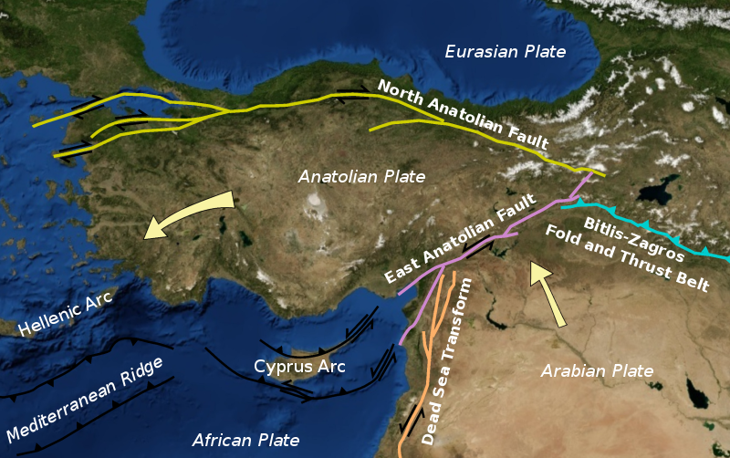
The United States Geological Survey (USGS) confirmed these quakes were occurring within the East Anatolian Fault System. This is a major strike slip fault zone that runs from eastern to south-central Turkey, forming the boundary between the Anatolian plate and the Arabian plate. This means these two plates are sliding past each other horizontally. This is similar to the San Andreas Fault in California. In this case, it's anticipated that the two plates slid 10 feet past each other during the earthquake.

Geologists with the USGS say that an earthquake of this magnitude is rare anywhere across the globe, but this type of event is not expected on a long plate-boundary strike-slip fault. The greatest earthquakes occur within subduction zones, not strike-slip faults.
The USGS has produced a ground failure report, which shows a significant area is exposed to landslides and liquefaction hazards as a result of the violent shaking. The report can be seen here: https://earthquake.usgs.gov/earthquakes/eventpage/us6000jllz/ground-failure/summary
How is it Measured?
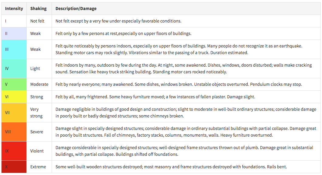
Earthquakes occur all across the globe on a daily basis. They're measured using a seismograph. This device measures the seismic waves traveling through Earth after an earthquake. Their waves are similar to ocean waves rippling across the planet. They then measure the waves using the MMI scale, or the Modified Mercalli Intensity Scale. The scale shows the magnitude, approximately how many people feel it, and what damage estimates may be. The intensity of shaking as a whole depends on more regional factors.

"The lower numbers of the intensity scale generally deal with the manner in which the earthquake is felt by people. The higher numbers of the scale are based on observed structural damage. Structural engineers usually contribute information for assigning intensity values of VIII or above."
What Happened?
There's a lot of speculation about what happened or worsen the effects of the earthquake. Timing was not great, as many people were inside and sleeping during the early hours. Some also speculate building codes may have had a lot to do with the amount of damage.
After the 1999 earthquake, officials reevaluated building codes in the area. The problem was, not all were built after 1999. Because it had been so long since an earthquake of this magnitude, older buildings were likely first to topple.

Not only was the quake itself devastating, but the weather that followed after didn't help. Temperatures were below freezing with falling rain and snow this week in the region. Those trapped under rubble now not only have to worry about food, water, and safety, but risk hypothermia. Civilians are urged not to stay indoors incase of another quake or aftershock, however, for some, being outside may be just as dangerous.
At the moment, rescue teams are still searching for survivors in Turkey and Syria. The president has also announced a three month state of emergency for the region affected.


